The Scale of the World: How the Victorians Mapped the Heights of the Andes and the Himalayas
In the summer of 1852, a climber named Charles Wills reached the summit of Ben Nevis — or so he believed. The exact height of Britain's highest mountain had been a matter of dispute for decades, and the surveys that would settle the question definitively were still years away. But the Victorian public's appetite for geographical knowledge was already insatiable, and the London publisher James Reynolds had found the perfect artist to satisfy it: a cartographer and illustrator named John Emslie, whose hand-colored comparative charts of the world's mountains were among the most beautiful and widely distributed geographical publications of the age.

The Comparative Chart as Victorian Art Form
The comparative mountain chart was a Victorian invention — or, more precisely, a Victorian perfection of an idea that had been developing since the late eighteenth century. Alexander von Humboldt had produced the first great comparative mountain diagram in his Essai sur la géographie des plantes (1807), a cross-section of the Andes that showed the distribution of plant life at different altitudes and placed the great peaks of South America in relation to each other for the first time. Humboldt's diagram was a scientific document; what the Victorian publishers did was transform the scientific document into a popular art form.
The key innovation was colour. Emslie's charts for James Reynolds were hand-colored with the kind of care and precision that made them objects of visual pleasure as well as geographical instruction. The mountains were rendered in profile, their heights depicted against a graduated scale, their names and elevations annotated with the meticulous clarity of the best Victorian educational publishing. The result was something that could be read as a chart — consulted for specific information about the height of a particular peak — and also simply looked at, as one looks at a painting, for the pleasure of the image itself.
The World in a Single Image
Emslie's world mountains and volcanoes comparative chart — reproduced on the back cover of our journal — is an exercise in radical compression. In a single image, it places the great peaks of four continents side by side: the Andes of South America, with Chimborazo and Aconcagua; the Himalayas of Asia, with Dhaulagiri and the peaks that would later be identified as the highest on Earth; the volcanic peaks of the Pacific and the Americas; the mountains of Africa and Europe. The British peaks of the front cover — Ben Nevis, Snowdon, Scafell Pike — appear here in their global context, dwarfed by the giants of the Andes and the Himalayas but still precisely measured, still given their proper place in the hierarchy of the world's heights.
This compression is the chart's great achievement. Before the age of photography and mass media, most people had no intuitive sense of the relative scale of the world's mountains. They knew that the Alps were high and the Andes higher, but they had no way of visualising the difference. Emslie's chart gave them that visualisation in an instant: a single glance was enough to understand that Ben Nevis, impressive as it was in the context of the British Isles, was a foothill compared to the great peaks of Asia and South America.
The Himalayas and the Limits of Victorian Knowledge
When Emslie produced his chart in 1850, the highest peaks of the Himalayas had not yet been measured with precision. The Great Trigonometrical Survey of India — the extraordinary project that would eventually identify Mount Everest as the highest point on Earth — was still in progress. The peak that would be named Everest was not identified as the world's highest mountain until 1852, and the name itself was not officially adopted until 1865. Emslie's chart therefore reflects the state of geographical knowledge at a specific moment of transition: a moment when the broad outlines of the world's topography were known, but many of the details were still being filled in.
This gives the chart a particular historical interest. It is not just a record of the world's mountains; it is a record of what the Victorians knew — and did not know — about the world's mountains in 1850. The peaks that appear on the chart are those that had been measured with sufficient precision to be included; the gaps and uncertainties in the data are as revealing as the data itself. Reading Emslie's chart today, we are reading a document of Victorian geographical knowledge at a specific moment in its development.
The British Peaks in Their Global Context
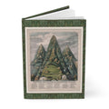
The front cover of our journal presents the companion chart: Emslie's Principal Eminences of the British Islands (1852), which documents the heights of Ben Nevis (4,413 ft), Snowdon (3,560 ft), and Scafell Pike (3,209 ft) alongside the lesser summits of the British Isles. Placed beside the world chart of the back cover, the British peaks acquire a double significance: they are, on their own terms, impressive and historically important mountains, the subjects of a growing Victorian passion for hillwalking and mountaineering; and they are, in the global context, modest elevations, their heights dwarfed by the great peaks of every other continent.
This double perspective — the local and the global, the familiar and the immense — is what makes Emslie's paired charts so satisfying as a visual and intellectual object. They invite the viewer to move between scales, to see Ben Nevis first as the highest point in Britain and then as a small hill in the context of the world, and to find in that movement between scales a kind of geographical education that no amount of text could provide as efficiently.
James Reynolds and the Geography of the Drawing Room
James Reynolds was one of the most important publishers of geographical and educational material in Victorian London. His Strand premises were a centre for the production and distribution of maps, charts, atlases, and educational prints that brought geographical knowledge to a middle-class public hungry for information about the world that British commerce and empire were opening up. Reynolds understood that geography was not just a school subject but a drawing-room interest — that the same public that read the accounts of Arctic explorers and Himalayan surveyors in the illustrated press would also buy beautiful hand-colored charts to hang on their walls or keep in their libraries.
Emslie's mountain charts were perfectly suited to this market. They were educational enough to be taken seriously, beautiful enough to be displayed, and accessible enough to be enjoyed by anyone with a general interest in the world. They are, in the best sense, popular science: the translation of specialist geographical knowledge into a form that the general public could understand and appreciate.
Our Mountains Journal reproduces Emslie's Principal Eminences of the British Islands (1852) on the front cover and his world mountains and volcanoes comparative chart (1850) on the back — a pair of images that together capture the Victorian ambition to map the scale of the entire world in a single, beautiful, hand-colored image.
References
Humboldt, A. von (1807). Essai sur la géographie des plantes. Paris: Levrault, Schoell et Compagnie.
Keay, J. (2000). The Great Arc: The Dramatic Tale of How India Was Mapped and Everest Was Named. HarperCollins.
Oliver, R. (1993). Ordnance Survey Maps: A Concise Guide for Historians. Charles Close Society.
Secord, J. A. (2014). Visions of Science: Books and Readers at the Dawn of the Victorian Age. University of Chicago Press.
Shortt, H. (1984). Victorian Cartography and the Popular Press. Map Collector Publications.