The Dutch Golden Age and Amsterdam's Dominance in World Cartography
In the first decades of the 17th century, the center of European cartography shifted decisively northward. The great Flemish mapmakers of the previous century — Mercator, Ortelius, Plantin — had established the southern Netherlands as the heart of European map publishing, but the fall of Antwerp to Spanish forces in 1585 and the subsequent migration of Protestant craftsmen and merchants to the northern provinces transformed Amsterdam into the new capital of European cartography, commerce, and culture. By 1620, Amsterdam was producing more maps, atlases, and geographical publications than any other city in the world, and it would maintain that dominance for the better part of a century — the period that historians call the Dutch Golden Age, and that produced some of the most beautiful and ambitious cartographic documents in the history of mapmaking.

The VOC and the Geography of Commerce
The foundation of Amsterdam's cartographic dominance was commercial rather than purely intellectual. The establishment of the Vereenigde Oost-Indische Compagnie — the Dutch East India Company, or VOC — in 1602 created an insatiable demand for accurate geographical information about the trade routes, coastlines, and harbors of Asia, Africa, and the Americas. The VOC maintained its own cartographic office, the Hydrographic Department, which collected and processed geographical intelligence from the company's ships and factors across the globe, and which produced the most accurate charts of Asian waters available anywhere in the world.
This commercial geography fed directly into the luxury map publishing trade that made Amsterdam famous. The great publishing houses — Blaeu, Hondius, Jansson — had access to VOC geographical intelligence that their competitors in London, Paris, and Rome could not match, and they used it to produce atlases and wall maps of a comprehensiveness and accuracy that established Dutch cartography as the global standard. Willem Blaeu's Atlas Novus (1635) and his son Joan's Atlas Maior (1662–65) — the largest and most expensive atlas ever published, in eleven volumes with 594 maps — were the supreme expressions of this tradition: works that combined geographical accuracy with decorative magnificence in a format that was simultaneously a reference work, a status symbol, and a work of art.
The Art of the Dutch Map
What distinguished Dutch Golden Age cartography from the work of its predecessors and competitors was not merely geographical accuracy but aesthetic ambition. The great Dutch maps were not simply navigational documents: they were decorated with allegorical border panels, cartouches, sea monsters, wind heads, and mythological figures that transformed them into works of art as much as works of science. The border decorations of the Blaeu atlases — with their personifications of the continents, their portraits of city views, their allegorical figures of the seasons and the elements — were designed by some of the leading artists of the Dutch Golden Age, and they reflect the same visual culture that produced Rembrandt, Vermeer, and the great tradition of Dutch painting.
The most celebrated of these decorative cartographers was Romeyn de Hooghe (1645–1708), the Amsterdam engraver, etcher, and political propagandist whose allegorical border illustrations for Gerard van Schagen's Nova Totius Terrarum Orbis Tabula of 1689 represent the final and most spectacular flowering of the Dutch decorative map tradition. De Hooghe was the most versatile and prolific printmaker of his generation — his output ranged from political satires and commemorative prints to book illustrations and architectural designs — and his border panels for the van Schagen map brought to cartographic decoration the full resources of the Baroque allegorical tradition: Roman gods on Mount Olympus, dramatic battle scenes, pastoral fields, ships navigating seas filled with mermaids and sea creatures, and mythological figures of extraordinary energy and invention.
Gerard van Schagen and the Nova Totius Terrarum Orbis
Gerard van Schagen (c. 1642–c. 1690) was an Amsterdam engraver and art dealer whose Nova Totius Terrarum Orbis Tabula of 1689 was based primarily on Frederick de Wit's maritime world map Orbis Maritimus of c. 1668 — itself one of the finest Dutch world maps of the mid-17th century. Van Schagen's contribution was to commission from Romeyn de Hooghe a set of allegorical border decorations that transformed de Wit's already distinguished map into something altogether more spectacular: a document that was simultaneously a geographical reference, a work of Baroque art, and a statement of Dutch cultural confidence at the height of the Golden Age.
The map's geographical content reflects the state of European knowledge in 1689 with characteristic Dutch accuracy and characteristic 17th-century limitation. California appears as an island — a misconception that had entered European cartography in the early 17th century and that persisted, despite mounting evidence to the contrary, until well into the 18th century. The coastlines of Australia and New Zealand are only partially mapped, reflecting the incomplete state of Dutch exploration of the southern Pacific. Antarctica is absent entirely. But the coastlines of Europe, Asia, Africa, and the Americas are rendered with a precision that reflects a century of Dutch maritime exploration and VOC geographical intelligence.
The Censored Map
The van Schagen map has a particular distinction in the history of cartography: its allegorical border decorations, with their Roman gods, mythological sea creatures, and Baroque allegorical figures, were considered so controversial — so flagrantly "heathen" — that they were removed from editions of the map included in Dutch Staten Bibles, the official Dutch Reformed translation of the Bible that was the most widely distributed book in the Netherlands. The censored editions, stripped of de Hooghe's magnificent decorations, survive in considerable numbers; the original version, with the complete allegorical programme intact, is significantly rarer — a document of the tension between Calvinist religious culture and the humanist, classicizing aesthetic of the Dutch Golden Age that makes it one of the most historically resonant maps of the 17th century.
The End of the Golden Age
The van Schagen map of 1689 appeared at the end of the Dutch Golden Age of cartography. The wars of Louis XIV, the financial strains of the late 17th century, and the growing competition from French and English map publishers — above all from the Paris publishing house of Guillaume Delisle, whose rigorous application of astronomical observation to cartography would transform the accuracy of European maps in the early 18th century — were already undermining Amsterdam's dominance. By 1700, the center of cartographic innovation had shifted to Paris, and the great tradition of Dutch decorative mapmaking was giving way to a new, more scientifically rigorous but aesthetically austere style of geographical publication.
Van Schagen's Nova Totius Terrarum Orbis stands, therefore, as a magnificent farewell to a tradition — the last great flowering of the Dutch decorative world map, combining the geographical knowledge of a century of maritime exploration with the allegorical imagination of the Baroque at its most exuberant. It is a document of a world still being discovered, mapped by a city at the height of its power, decorated by an artist at the height of his art.
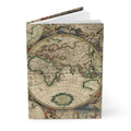
If the Dutch Golden Age and the art of cartography inspire you, our World Map Journal — Van Schagen 1689 Nova Totius Dutch Golden Age brings the complete double-hemisphere map to the cover of a hardcover journal.
References
- Koeman, C. Atlantes Neerlandici. Theatrum Orbis Terrarum, 1967–71.
- Shirley, R. W. The Mapping of the World: Early Printed World Maps 1472–1700. Holland Press, 1983.
- Schilder, G. Monumenta Cartographica Neerlandica. Canaletto, 1986–2013.
- Israel, J. I. The Dutch Republic: Its Rise, Greatness, and Fall 1477–1806. Oxford University Press, 1995.
- Zandvliet, K. Mapping for Money: Maps, Plans and Topographic Paintings and Their Role in Dutch Overseas Expansion during the 16th and 17th Centuries. Batavian Lion International, 1998.