The Language of Flags: J. H. Colton’s 1863 Chart and the Vexillological World of the Nineteenth Century
I. The Port as Classroom
In the mid-nineteenth century, the waterfront of New York Harbor was one of the most cosmopolitan places on earth. Ships arrived daily from Liverpool and Hamburg, from Havana and Valparaíso, from Yokohama and Bombay, from ports whose names most New Yorkers could barely locate on a map. Each ship flew a flag — sometimes several — and the ability to read those flags was not an academic exercise. It was a professional necessity.

Harbor pilots, customs officers, merchants, and dockworkers needed to know, at a glance, what flag a ship was flying, what nation or company it represented, what legal regime governed its cargo, what language its captain spoke. The flag was the first communication between a ship and the shore — a visual signal transmitted across water before any voice could carry.
It was to serve this practical need that publishers like J. H. Colton produced their charts of national flags. These were not decorative objects, though they were often beautiful. They were working documents — reference tools for a world in which maritime commerce was the primary engine of global trade, and in which the ability to identify a flag could mean the difference between a profitable transaction and a diplomatic incident.
II. J. H. Colton and the New York Cartographic Tradition
Joseph Hutchins Colton (1800–1893) was one of the most prolific and influential map publishers in nineteenth-century America. Based at 172 William Street in lower Manhattan — in the heart of the city’s publishing district, a short walk from the waterfront — his firm produced atlases, maps, and geographical reference works that were distributed across the United States and exported to Europe.
Colton’s output was extraordinary in its range. He published road maps and railway maps, county atlases and world atlases, school geographies and navigational charts. His firm was among the first in America to adopt the new techniques of chromolithographic printing, which allowed maps and charts to be reproduced in multiple colors at a scale and quality that earlier printing methods could not achieve.
The National Flags chart, published around 1863–1866, belongs to this tradition of practical geographical reference. It was produced during one of the most turbulent periods in American history — the Civil War was still being fought when the first editions appeared — and it reflects the particular anxieties and ambitions of that moment: a nation at war with itself, simultaneously asserting its place in the global order and uncertain of its own future.
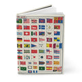
III. What the Chart Shows
The Colton National Flags chart is a vexillological document of extraordinary richness. It shows more than a hundred national and commercial flags from across the world, organized by region and type, with the flags of the major maritime powers given the most prominent positions.
At the top of the chart, a row of signals for pilot boats — the small vessels that guided larger ships into harbor — reminds the viewer of the chart’s practical purpose. These were the flags that a harbor pilot needed to recognize first, before any national ensign: the signals that governed the immediate business of navigation.
Below them, the national flags of the world’s powers are arranged in a hierarchy that reflects the geopolitical realities of the 1860s. The flags of the United States and the major European powers — Britain, France, Prussia, Austria, Russia — occupy prominent positions. The flags of smaller nations, colonial territories, and commercial companies fill the remaining space.
IV. The Flags That No Longer Exist
What makes the Colton chart most valuable as a historical document is not what it shows about the world as it is, but what it shows about the world as it was — and, by implication, about how much has changed.
The chart includes the flag of the Russian-American Company — the joint-stock company that administered Russian Alaska until its sale to the United States in 1867. The company’s flag, a distinctive design combining Russian imperial elements with the company’s commercial insignia, was a familiar sight in the ports of the Pacific Northwest. Within a few years of the chart’s publication, it would disappear entirely, replaced by the Stars and Stripes as American sovereignty extended to the territory the Russians called Alyaska.
The flag of Siam appears with its white elephant on a red ground — the emblem of the Kingdom of Siam that would remain in use, in various forms, until the country’s name was changed to Thailand in 1939. The elephant flag is one of the most visually striking on the chart, and one of the most historically resonant: it represents a kingdom that successfully resisted European colonization throughout the nineteenth century, maintaining its independence through a combination of diplomatic skill and strategic modernization.
The chart also reflects the complex flag politics of the American Civil War. Colton, as a New York publisher, navigated the question of Confederate representation carefully — the 1863–1865 editions of the chart typically omit the Confederate battle flag, a political choice that speaks to the publisher’s loyalties and to the commercial realities of publishing in a Union city during wartime.
V. Vexillology as History
The word vexillology — from the Latin vexillum, the standard carried by a Roman military unit — was coined only in 1957, by the American scholar Whitney Smith. But the study of flags is as old as flags themselves, and the practical need to identify and classify the flags of the world’s nations has driven the production of reference charts since the age of sail.
The nineteenth century was the golden age of vexillological publishing. The expansion of global trade, the proliferation of new nations (particularly in Latin America, following the independence movements of the 1810s and 1820s), and the development of chromolithographic printing all contributed to a demand for accurate, up-to-date flag charts that publishers like Colton were well positioned to supply.
These charts were not merely practical tools. They were also expressions of a particular vision of the world — a world organized into sovereign nations, each with its own flag, its own commercial identity, its own place in the hierarchy of global power. The chart is a map not of territory but of sovereignty: a visual representation of the political order of the mid-nineteenth century, frozen at a particular moment and preserved in ink and paper.
VI. The Pilot Boat Signals
The row of pilot boat signals at the top of the Colton chart deserves particular attention. Pilot boats were the first vessels to meet an incoming ship — small, fast, and crewed by men whose knowledge of local waters was essential to the safe navigation of larger vessels into harbor. The signals they flew, and the signals they recognized, were a specialized visual language within the larger language of maritime flags.
The inclusion of pilot boat signals in a general flag chart reflects the chart’s intended audience: not the casual observer, but the working mariner or harbor professional who needed to understand the full range of visual communication that governed life on the waterfront. It is a reminder that the chart was a tool, not a decoration — that the beauty of its chromolithographic colors was incidental to its function as a reference document.
VII. The Chart as Time Capsule
To look at the Colton National Flags chart today is to look at a world that no longer exists. The Russian-American Company is gone. The Kingdom of Siam has become Thailand. The German states that appear as separate entities on the chart were unified into the German Empire in 1871. The Ottoman Empire, whose crescent flag appears prominently, dissolved after the First World War. The British Empire, whose flags occupy a significant portion of the chart, has been replaced by a Commonwealth of independent nations.
What remains is the chart itself — a document of extraordinary historical specificity, a snapshot of the world’s political geography at a moment of extraordinary flux. The flags it shows are not merely symbols; they are evidence. They tell us who existed, who was recognized, who was powerful, and who was invisible in the world of 1863.
That is the peculiar value of vexillological documents: they are among the most honest records of political reality that history has produced. A flag cannot lie about its own existence. If it appears on a chart, it was real — recognized, flown, seen in the harbors of the world. And if it no longer appears on any chart, it is because the entity it represented has ceased to exist.
VIII. A Note on This Journal


The cover of this journal carries J. H. Colton’s National Flags chart of c.1863–1866 — a vexillological document produced in New York at the height of the Civil War, showing more than a hundred national and commercial flags from a world that has since been transformed beyond recognition. For historians, maritime enthusiasts, and anyone drawn to the flags that no longer fly.
👉 National Flags Journal — J. H. Colton c.1863
References
- Colton, J.H. (c.1863–1866). National Flags. J. H. Colton & Co., New York. David Rumsey Map Collection.
- Smith, W. (1975). Flags Through the Ages and Across the World. McGraw-Hill.
- Osher, D. & Garvin, J. (2003). Putting the World in Order: Maps from the Collection of David Rumsey. David Rumsey Map Collection.
- Modelski, A.M. (1984). Railroad Maps of North America: The First Hundred Years. Library of Congress.
- Gibson, A. & Pinfold, J. (2011). The Flag Bulletin. Flag Research Center.
- David Rumsey Map Collection. J. H. Colton National Flags, 1863. davidrumsey.com.